
Mt.Daedeok


MUJU COUNTY
Pure Muju
Muju as a Tourist Attraction
Muju in the History
Muju under the Four Seasons
Introduction to Muju
How to Find Us
Tourist Information Center
Major Tourist Attraction
33 Scenic Spots in Gucheon-dong
Noted Mountains in Muju
Valleys in Muju
Noted Amusement Parks
- Muju Deogyusan Resort
- Bandi Land
- Taekwondo Park
- Gucheondong Tourism Complex
- Deokyudae Comprehensive Camping Ground
- Bunam Riversides Amusement Park
- Muju Hydro-Pover Generation Plant
Cultural Heritage Sites
Confucian Academies/Buddhism Temples
Natural Monuments
Leisure/Sports
Muju Resort
Mountaineering
Tasty Foods in Muju
- Fish Gruel
- A Korean Table D'horte, 'Sanche Bibimbap'
- Sanchae Jeongsik
- Freshwater Fish Red-pepper Pot
- Oak Mushroom & Rice Soup
Festivals/Cultures
Firefly Festival
Education Center of Traditional Culture
Banditbul
Noted Mountains in Muju
Mt. Daedeok
Daedeok Mountain
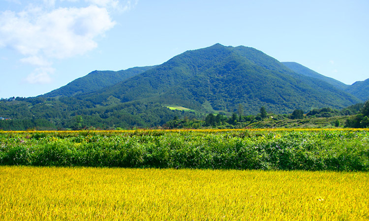
Mt. Daedeok (1,290m), which is located at the utmost east region of Muju-gun, is a renowned mount next to Mt. Chocheom (1,250m above sea level), which is a branching area of the three provinces dividing Gimcheon in Gyeongsangbuk-do and Geochang in Gyeongsangnam-do, at the sides of the ridge of Mt. Daedeok stretching toward Mt. Gaya.
It was called 'Darak Mountain' or 'Daak Mountain' in ancient days and has been known that there once was an weather alter. This mount looking gentle, but being accompanied with tactless masculine virtue has trained numerous talented people since long time ago and, especially, Mupungdong where this mount is located is a famous region known as one of the 12 Earth's Branches defined by an epidemiologist, Mr. Nam Sa-go.
| Location | Deokgi-ri, Mupung-myeon, Muju-gun, Jeollabuk-do, 568-822 |
|---|---|
| Transportation | Downtown of Muju-eup ⇒ Mupung-myeon: 27kms (It takes around 40min. by bus.) the Seat of Mupung-myeon ⇒ Dogae Village in Deokji-ri: 9.5kms (taking 20 min. by bus) |
| Hiking Course | Dogae ⇒ Doma Village (Entrance): 1km ⇒ at a fork of the ridge: 2kms ⇒ at another fork of the ridge: 1km (total 4kms)
|
Copyright(c) MUJU County. All rights reserved.