
Mt.Johang


MUJU COUNTY
Pure Muju
Muju as a Tourist Attraction
Muju in the History
Muju under the Four Seasons
Introduction to Muju
How to Find Us
Tourist Information Center
Major Tourist Attraction
33 Scenic Spots in Gucheon-dong
Noted Mountains in Muju
Valleys in Muju
Noted Amusement Parks
- Muju Deogyusan Resort
- Bandi Land
- Taekwondo Park
- Gucheondong Tourism Complex
- Deokyudae Comprehensive Camping Ground
- Bunam Riversides Amusement Park
- Muju Hydro-Pover Generation Plant
Cultural Heritage Sites
Confucian Academies/Buddhism Temples
Natural Monuments
Leisure/Sports
Muju Resort
Mountaineering
Tasty Foods in Muju
- Fish Gruel
- A Korean Table D'horte, 'Sanche Bibimbap'
- Sanchae Jeongsik
- Freshwater Fish Red-pepper Pot
- Oak Mushroom & Rice Soup
Festivals/Cultures
Firefly Festival
Education Center of Traditional Culture
Banditbul
Noted Mountains in Muju
Mt. Johang
Johang Mountain
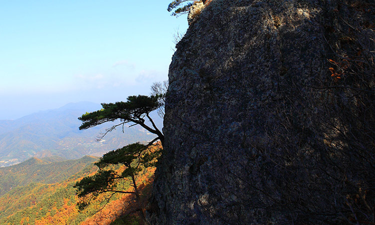
Mt. Johang (799.3m) is located at the boundary between Bunam-myeon and Jeoksang-myeon, Muju-gun passing along with Mt. Dumun, Anseongchi, Joduchi, Mt. Bonghwa and Mt. Buldang starting from the Hyangjeok Peak of the Deokyu Mountains.
If Mt. Johang were translated into Korean, it means 'Saemok' and it is also called 'Gitdaebong' or 'Gukgibong' since it was surveyed while flagpoles are erected by Japanese surveyors under the Japanese rule. When standing on the top of it, you can look down the whole open brilliant views in all of the directions. From the north, a chain of peaks, Seokgi Peak and Samdo Peak of Mt. Minjuji come near into sight amicably.
When turning the head to the east, the lines of branch ridges of 'Baekdudaegan' (White Head Great Ridge), which ranges from Mt. Jeoksang to Mt. Nam-Deokyu via Hyangjeok Peak from afar, dance with swaying the limbs. To the west, Mt. Jijang, which embraces Oknyeo Peak and Mt. Jiso, is located very closely to it and also behind the Mt. Jijang, Mt. Unjang and Mt. Mai, with its two pricked-up horse ears are caught on eyes at a sight. A watercourse of Geum River (Geumgang), which has flown down via Juk-do after being originated from Subunryeong in Jangsu-gun, Jeonlabuk-do, flows around the foot of the mountain and it is hugging the picturesque scenary of the 'Jukdampalgyeong' (8 scenic spots of Jukdam) in the Jukdam Valley.
| Location | Mt. Johang, Daeso-ri, Bunam-myeon, Muju-gun, Jeollabuk-do, 568-852 |
|---|---|
| Transport | Muju ⇒ (9.5kms) ⇒ Gadang-ri (the Seat of Bunam-myeon, taking 40min. by bus) |
| Accommodation | Available for homestay facilities in Bunam-myeon |
| Information Desk | Bunam-myeon Office ((+82) 063-320-2606) |
| Hiking Course |
|
Copyright(c) MUJU County. All rights reserved.