
Location/Topography


MUJU COUNTY
Pure Muju
Muju as a Tourist Attraction
Muju in the History
Muju under the Four Seasons
Introduction to Muju
How to Find Us
Tourist Information Center
Major Tourist Attraction
33 Scenic Spots in Gucheon-dong
Noted Mountains in Muju
Valleys in Muju
Noted Amusement Parks
- Muju Deogyusan Resort
- Bandi Land
- Taekwondo Park
- Gucheondong Tourism Complex
- Deokyudae Comprehensive Camping Ground
- Bunam Riversides Amusement Park
- Muju Hydro-Pover Generation Plant
Cultural Heritage Sites
Confucian Academies/Buddhism Temples
Natural Monuments
Leisure/Sports
Muju Resort
Mountaineering
Tasty Foods in Muju
- Fish Gruel
- A Korean Table D'horte, 'Sanche Bibimbap'
- Sanchae Jeongsik
- Freshwater Fish Red-pepper Pot
- Oak Mushroom & Rice Soup
Festivals/Cultures
Firefly Festival
Education Center of Traditional Culture
Banditbul
Location/Topography
Location/Topography
Muju harmonizes east and west, where the 3 provinces, Chungcheong/Jeolla/Gyeongsang, meet.
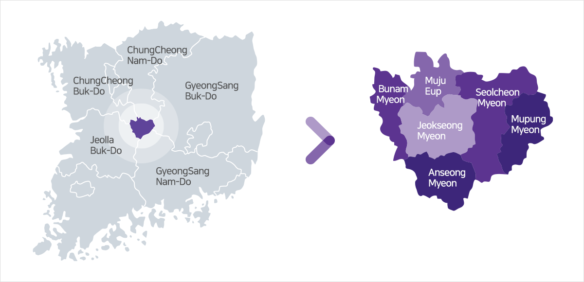
muju-gun topographic map 2 : Image Description
- Left map - Explain clockwise around Muju
- Chungcheongnam-do, Gyeongsangbuk-do, Gyeongsangnam-do, Jeollabuk-do, Chungcheongbuk-do
- Right map - Explain clockwise around Jeoksang-myeon
- Muju-eup, Seolcheon-myeon, Mupung-myeon, Anseong-myeon, Bunam-myeon
Mugu-gun is centrally located where 5 provinces -Gyeongsangnamdo, Gyeongsangbukdo, Jeollabukdo, Chungcheongnamdo and Chungcheongbukdo – and 7 cities and guns (districts) meet. Since December 1997, with the opening of the Daejeon-Jinju highway that forms the north-south axis, Muju can be reached within 2 hours from anywhere around the country including Seoul and Busan. With easy accessibility, it hold send less development potentialas the central location of in land traffic.
Located atthefar north east ernend of the Sobaek Mountain Range, Muju shares its boundary with Gyeongsangnamdo, Gyeongsangbukdo, Chungcheongnamdo and Chungcheongbukdo. Inaddition, the national park of Deogyusan(Mt.Doegyu) is famous for its beautiful scenery in each of the four seasons. The over allarea amounts to 631.7km2 which is 27km2 wider than the total area of Seoul, but the region is apleasantrural district with a population of only 31,000. Currently, the size of its budget is 107.5billion won and the industry consists of 52% primary industry, 2% secondary industry and 46% tertiary industry.
Based on the characteristics of its mountain ousarea, the industrialization of the regionhasfailed. The geographical coordinates of Muju is 127˚ 55' ~ 127˚ 31' in east longitude and 36˚ 4' ~ 36˚ 47' in north latitude, which is the most central mountainous region among Korea’s inland districts. The four seasons of Muju resemble a young maiden changing clothes of all styles and colors.
Copyright(c) MUJU County. All rights reserved.